
[Messageboard]
![]()
|
|
Location:
close to the matheran hill station is a little known but relatively easy
trekking fort called peb. Hike
duration:
one day for a quickie trek but overnight stay is definitely recommended. Geographical
proximities: Peb
fort seems to be on the continued limb of the kalyan – karjat mountain range
which roughly lies perpendicular to the sahyadri ranges. The peaks of this short
range, each have a name and some are of historical significance. This range runs
in the north - east to south - west direction (kalyan to karjat) as opposed to
the sahyadris which run in the
north south direction. The
peaks are:
Routes
to arrive at
the hiking spot:
Best
time of the year to visit: Since
this region is relatively better off as regards basic amenities are concerned
with respect to some other parts of interior maharashtra. Water and food both
may be plentiful just in case they are needed. Except
for may be the dry months of may – june water is available rest of the year.
The best time to visit the fort or its surroundings is from august to december. It
is better to avoid the very wet months of june and july as some of the paths and
trails may be slippery and dangerous. Journey
: Neral
– peb route: Arrive
at neral station by train (central railway) by boarding the “karjat
local” which starts from C.S.T
and halts at byculla, dadar, kurla,
ghatkopar and thane. Cross
over to the east side of the station where the market place is located.
The
notch between nakhind and peb is the one to catch site of as this is the final
destination. The notch has a hillock so the space between nakhind and peb is
actually a stretched out “W”. remember that we will begin to climb so that
we reach the left wing. The right wing has a high tension electric pylon on it
and is the approach for the neral – nakhind- peb route. The
route is well used and so it is not a problem once you set out right from neral.
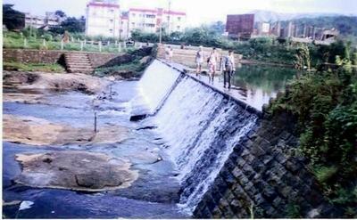
After crossing the dam head for a small hamlet and then cross the river again
to go over to the other side. Here follow the trail up as it begins to ascend
the route intercepts 2 pylons and runs roughly
parallel to the high voltage line for some distance.
However
there are 4 signs which will tell you that you are on the right track: 1.The
direction of the path is always toward the left wing of the “w” After
climbing few broken steps which have been carved out of rock, the cool breeze
welcomes us as we finally reach the notch and the entire landscape on the west
of the mountain opens out in to the view. If climbing was started at late noon
time, it’s a rewarding site to see the sunset. The
path here is actually a kind of a cross road the route turning right goes to
nakhind, the one straight comes from “savtyachi wadi”, but we have to take
the left turn and start the final ascent to the fort. Only
one obstacle now remains to be crossed that’s a 8 foot high rock cliff
which has to be climbed over using basic climbing skills (however its good to be
alert when crossing this point, as a funny anecdote relates to a colleague’s
knapsack tumbling over this point only to be lost forever, as
the cliff here is pretty steep). After
this small adventure the rest of the way is very easy and is on flat ground,
however we have to be alert while moving ahead as the path suddenly bifurcates
and we shall have to take the left climbing path which leads to the cave. Things to see: The
cave
is bicameral and very commodious. Occasionally the cast iron gate to entrance of
the cave is locked but there is plenty of space in front of the cave for camping
too. The
view of the vast expanse of the western horizon is breath taking and on a clear
day it is easy to appreciate a far as the sea, on clear nights the blinking of
the tata electric company’s chimney at chembur / trombay can also be
appreciated at a distance. The view is absolutely fantastic
and words would not do justice to something so beautiful and which can be easily
experienced by anyone. The
way to the fort proper is to continue straight with out taking a left turn for
the caves. As we proceed further we come across a stone wall on the left this is
the way we will have to climb up to the fort, there are long nails hammered into
the rock, so climbing it is kind of exciting. On
the top of the mountain there is not much to appreciate except an old temple
where “Shiva “ is the main deity there is no roof here. On
the north side facing the Panorama point are remains of broken
fortification which are probably only evidence of it being a fort. The
entire round on the top takes about 15 to 20 minutes.
Image
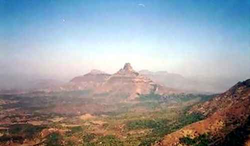
above : Chanderi as seen from the Peb fort.
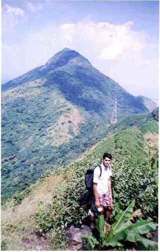
Image
: Nankhind as seen from the Peb fort.
Trek
scale: Relatively
easy, water and place to camp present, trek itself does not take more than 2 to
3 hours at a fast pace. -Rohit
Divekar.
|